Let’s just say that the handling of the Geopark proposal was not one of the Thompson-Nicola Regional District’s finest moments.
READ MORE: TNRD to use reverse petition for geopark proposal
The most likely explanation of it all was that the TNRD staff were still busy with the wildfire situation, there was a budget deadline approaching, and those responsible didn’t have the time to consider the whole matter with as much care as they no doubt would have liked to.
As it ended up, the vote count in a “negative petition” that ended Sept. 5 showed far more than 10 per cent of those living within the service area for the Geopark did not want to pay for it through their taxes.
The Geopark proposal combined two very good ideas into one that, while it did have some merits, didn’t really jump out and sell itself to the electors.
The first of the two good ideas was the Geopark proposal first put forward about 10 years ago.
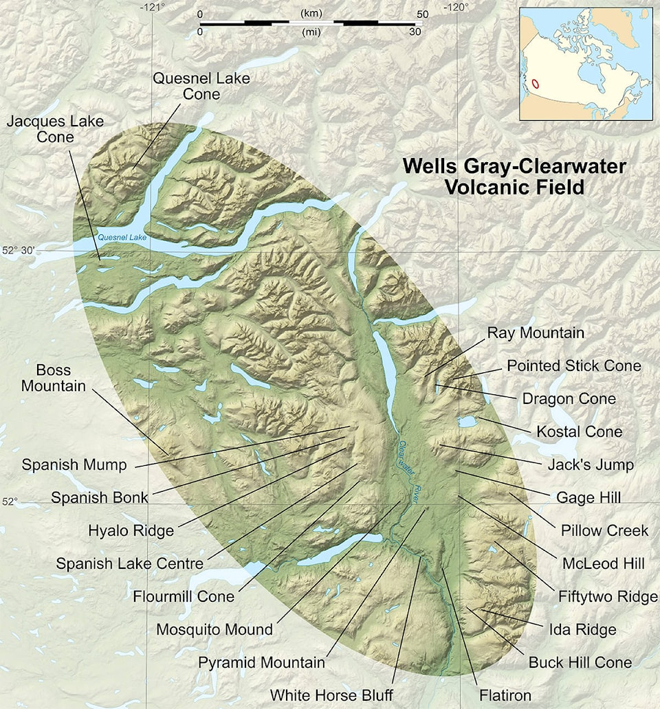
That began with efforts to save Buck Hill, a small cinder cone on the west side of Trophy Mountain.
One of the reasons for doing so put forward at the time was the possibility of Wells Gray Park and its associated volcanoes becoming a UNESCO World Heritage Site.
That soon proved to be too expensive a proposition and so the idea was scaled back (at least temporarily) to seeking UNESCO Geopark status.
A Geopark has been defined as an area recognized by the Global Geoparks Network as having geological heritage of international significance.
There are 22 identified volcanic vents in or near the park, many of which developed under glaciers.
One stumbling block in the proposal was about half of the volcanic features are on the west side of the Clearwater River, making them difficult to access.
The second was the question of who should pay for it.
Part of the volcanic field is in TNRD, part is in Cariboo Regional District, and part in the middle is under BC Parks or provincial jurisdiction.
At about the same time, the regional district was working with the provincial government and communities in the North Thompson and Robson valleys to develop what was called the Barriere-to-McBride economic development corridor.
This was another good idea, because the communities of the North Thompson and Robson valleys share many of the same problems and, presumably, could share solutions as well.
Somehow, the two ideas got linked and the Geopark proposal, instead of focussing on the volcanoes of Wells Gray Park and area, became centered on the North Thompson Valley. The volcanoes became secondary.
It’s time to go back to basics.
Let’s make the Geopark proposal into two again.
First, let’s have a vote to set up an economic development service area for the North Thompson Valley.
That economic development service should work on tasks such as the Barriere to McBride mountain bike network, improving Internet access, and getting better electrical power.
One task would be to work with Cariboo Regional District, BC Parks, Thompson Rivers University and others to develop a Geopark application for the Wells Gray-Clearwater volcanic field.
Part of that development process should be lobbying to get a bridge across the Clearwater River.
That road would give access to the Flourmill Cone and other volcanic features on the west side of the river.
It also would provide a possible escape route in the event of a forest fire in Wells Gray Park.