Cam Fortems – Kamloops This Week
The North and South Thompson watersheds have the highest snowpacks in a province that is rapidly drying out.
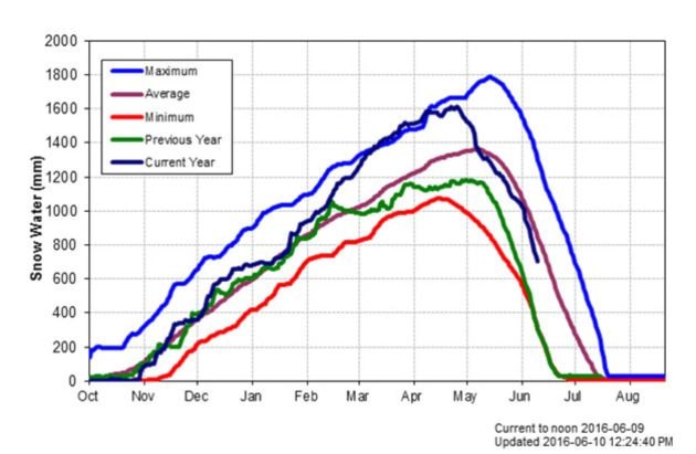
In its latest bulletin, the B.C. River Forecast Centre noted the alpine snowpack “continued to melt at a rapid rate.” Levels are extremely low in most of the province, including the Okanagan at 26 per cent of normal, East Kootenay at eight per cent and Vancouver Island at 28 per cent.
The North and South Thompson, in the upper 60 per cent range of normal, are the highest in B.C.
“The 30-plus degree weather didn’t do us any favours,” said Kevin Boon, general manager of the B.C. Cattlemen’s Association.
Hot weather spells in April, May and this month caused rapid snow melt. Boon said the same hot weather caused an increase in hay production for ranchers. That has produced the tantalizing possibility of adding another cut — if there is enough water to irrigate later in the year.
“Things are just early,” Boon said.
The river forecast centre warned in its bulletin that “flows in June, July and August that are derived from snow melt will be greatly reduced.”
Seasonal forecasts from Environment Canada predict above normal temperatures across B.C. through August.
Boon said ranchers at risk from drought tend to be in valleys, where they rely on rivers that may run too low. The province can order water users to cease pumping in order to improve fish habitat, as it did last year in various areas of the Interior.
Shuswap Lake conservationist Jim Cooperman said the popular recreational water body is higher, earlier than normal. He attributed the early melt to climate change.
“The biggest impact will be on recreation,” he said, noting sand is typically trucked in to Canoe beach to cover mud.
“It will be well into mud by August,” Cooperman said.
But both Cooperman and Boon said much depends on the amount of precipitation that falls this summer. June is historically Kamloops’ rainiest month.
Ranchers who are at higher elevations can use existing dams to retain water later into summer. Boon said the association is pushing the province to allow ranchers more ability to create storage and hold back water.
He said that can create advantages for other values, including increasing stream flows in August to help fish and providing more durable wetland habitat.