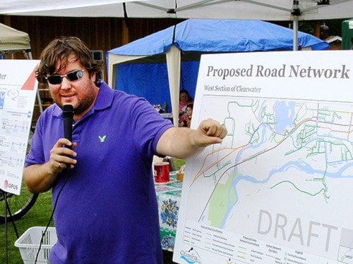
A draft roads and trails plan for Clearwater proposes some interesting and far-reaching changes for the community.
Details of the plan, which is being developed by Opus International for the municipality, were unveiled during a mobile open house held Saturday.
Nearly 20 people walked or cycled from the Farmers Market to Dutch Lake beach, Weyerhaeuser subdivision and then Rotary Sports Park to take part.
The roundabout presently under construction at the junction of Highway 5 and the road to Wells Gray Park could be just the start in far-reaching changes to the transportation network in the community.
For example, the plan shows a proposed right-turn only on/off access to Highway 5 between the courthouse and Wells Gray Inn to accommodate a shopping center proposed for the area.
It also shows extensions of Woreby Road that would give access to the proposed BearView shopping center to Highway 5 at Eden Road and to Park Drive.
Several options for Robson and Murtle roads were presented. These ranged from narrowing them to effectively one lane to slow traffic, to widening them to add parking space plus adding cycling and walking paths along the side.
Similar options could be used for Old North Thompson Highway by Dutch Lake beach, and for other roads within the municipality.
An important feature of the plan would be development of a spine of cycling and walking paths through the center of the community, from North Thompson Provincial Park to Miller subdivision.
Being able to walk or cycle from the campground to the shopping center would be a huge advantage for the community, one participant observed.
The spine would include a footbridge over Raft River next to the viewing platform.
Part of the funding for the planning project is coming from Interior Health.
The health agency has an interest in promoting more walking and cycling, and in the development of safer streets, said community health representative Jenny Turco.
Today only 34 per cent of children in B.C. walk or cycle to school, compared to 80 per cent in the 1970s.