lThe provincial Environmental Assessment Office (EAO) wants Yellowhead Mining to go back to the drawing board with its application for its proposed Harper Creek copper-gold-silver mine southwest of Vavenby.
The EAO announced May 17 that it has concluded that the application for an Environmental Assessment Certificate for Harper Creek does not satisfy the application information requirements (AIR) and has decided not to accept the application for review.
In a letter to Charlene Higgins, Yellowhead Mining's vice-president for environment, community and First Nations relations, project assessment manager Gerry Hamblin wrote, “EAO has concluded that the application does not provide an appropriately meaningful treatment of the requirements of the AIR, and has decided not to accept the application for review.”
Attached to the letter were six documents from agencies identifying deficiencies in the application.The EAO provided a 60-page table of concordance that includes information that it feels the application lacks.
For example, the application say a mining access road would be created through improvements to existing roads plus a 2.5 km road section constructed near the mine. The assessment office asked for more details on what those improvements would be.
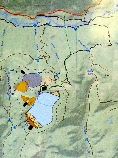
The application says a new 138 kV power-line 12 km long would connect the mine with a BC Hydro sub-station. Yellowhead was asked to provide a detailed map.
Ministry of Energy, Mines and Natural Gas noted that characterization data indicates that some of the weathered bedrock is potentially acid generating (PAG) and some of the overburden has elevated levels of leachable copper, selenium and zinc. EMNG asked for additional details in how metal leaching and acid rock drainage would be managed.
A letter from SRK Consulting said that a very large earth-fill dam would be constructed to hold the mine's tailing pond. This dam would start at 70 m in height but would gradually be raised until it was 180 m in height.This would qualify it as a “very high” under the Canadian Dam Association's safety guidelines. The consultant asked for further information to ensure the dam would be safe.
Two rock cairns have been found within the proposed mine area, said the Archaeology Branch of the Ministry of Forests. Lands and Natural Resources.The Branch noted that it is not known if the rock features are burial cairns as asserted by Simpcw First Nation, historic period burial cairns associated with mining or ranching, or some other feature such as trap caches.
Interior Health said the application needs to evaluate the potential impacts on the transportation corridors, traffic flow for all modes of transport, air quality and noise.The application's groundwater study does not elaborate on the potential impacts on the aquifer, the health authority wrote.
Simpcw First Nation submitted a list of 14 comments. These included the absence of costing for decommissioning closure/abandonment/reclamation. Also missing was a wildlife compensation plan.
Yellowhead’s proposed Harper Creek copper-gold-silver mine would be located about 10 km southwest of Vavenby.According to the company, there would be 600 jobs created during the construction phase. Most of these would live in a camp at the mine-site, but there still would be money added to the local economy.
Once the mine was operational, there would be about 430 jobs in the mine, in the mill and in administration.Added to this would be 860 to 1,200 indirect jobs in nearby towns.