Update: A fire reported near Candle Creek on July 11 is now out, according to the BC Wildfire Service.
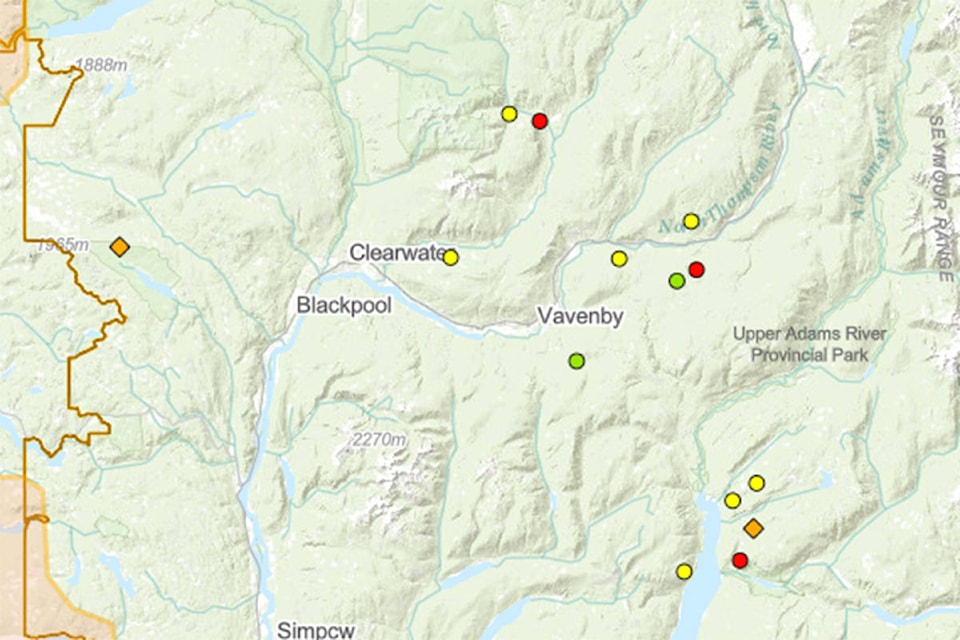
There are eight wildfires burning in the Clearwater and Vavenby areas, according to the app, and five more are burning on the north end of Adams Lake.
Two fires are considered under control, one near Chuck Creek which is two hectares in size and another by Homestead Forest Service Road at 0.6 hectares.
A wildfire across the highway from Birch Island (0.009 hectares) is being held, as are three others in the area, including one near Raft River north Vavenby (0.1 ha), another near Road 2612 (0.009 ha) and the last in the Hornet Creek (0.009 ha) area.
A wildfire started by lightning in the Cariboo Otter FSR area is still considered out of control and is 50 hectares, as is a fire west of Raft River and north of Highway 5 which is also 50 hectares.
For a list of current wildfires, visit the BC Wildfire Service dashboard or view the list.
EARLIER
July 7: Fire crews have taken control of a few more fires in the upper North Thompson region.
Ten fires are noted on the BC Wildfire Service dashboard, just three of which are deemed “out of control.” These include two fires, one at 0.1 hectares and the other at 0.009 hectares, west of Raft River and a third near Cariboo/Otter FSR that has grown to 50 hectares.
A 0.009-hectare wildfire across the highway from Birch Island is “being held,” along with two other 0.009-hectare fires, one near Road 2612 and the other near Hornet Creek. Two remaining fires on the north end of Adams Lake are also being held, both 0.1 hectares and near Cannon Mountain.
Two fires, one near Chuck Creek at 2 hectares and the other near Homestead FSR at 0.6 hectares, are “under control.”
Anyone who has questions regarding evacuation procedures, contact the District of Clearwater, if within the boundaries, at 250-674-2257. If you’re outside the DOC boundaries, call the Thompson-Nicola Regional District office at 250-377-8673 or their emergency line at 1-866-377-7188 or email emergency@tnrd.ca.
For a list of current wildfires, visit the BC Wildfire Service dashboard or view the list.
July 8, 3:35 p.m.: Firefighting actions appear to be working on a few wildfires in the upper North Thompson region.
The number of fires burning in the area has gone down to 11 as two wildfires near the north end of Adams Lake have disappeared from the map. One of them was noted as “being held” just yesterday (Wednesday). The status and size of the remaining two have not changed.
Another wildfire in the Adams River area is 0.009 hectares and “under control.”
Five fires are still burning in the Vavenby area, one of which is being held. This fire is near the Homestead FSR, is 0.6 hectares in size and lightning is the suspected cause. It was reported on July 2. Two other fires were reported on July 2, one near the Cariboo/Otter FSR, which is 0.1 hectares in size and another near Chuck Creek, 2.0 hectares in size. Both were caused by lightning and noted as out of control by BC Wildfire Service.
Another, near Road 2612, is 0.009 hectares in size with an unknown cause. This fire was discovered on July 4. The fifth wildfire was reported July 5 is near Hornet Creek, is 0.009 hectares in size, is noted as out of control and the cause also is unknown.
The last three fires are in the Clearwater area. The first is west of Raft River, 0.009 hectares in size and the second is near Birch Island and is also 0.009 hectares in size. Both are noted as out of control and the causes are unknown at this time. The last is reported as north of Vavenby, 0.1 hectares in size and noted as out of control, according to BC Wildfire Service. The fire was reported on July 4 and the cause is unknown at this time.
ALSO READ: Do you know your B.C. wildfire terminology?
July 7 12:49 p.m.: Fire crews are slowly obtaining some control over the fires that popped up in the upper North Thompson Valley over the last week.
Thirteen fires are currently burning in the region from the north end of Adams River, northeast of Vavenby and north of Clearwater, according to BC Wildfire Service. Ten of the fires are noted as “out of control” and three are “being held.”
In the Adams Lake area, five fires are burning. One near Adams River, reported July 2, is 0.009 hectares is size, noted as out of control and lightning in the suspected cause.
Three were reported on July 3, one near Honeymoon Forest Service Road, noted as being held, 0.1 hectare in size and another on Cannon Mountain, also 0.1 hectares in size and deemed out of control. The cause of both is suspected to be lightning. The third is near Gordon Creek, also noted as being held, is 0.009 hectares in size but the cause is unknown.
The last fire in this area was reported on July 5 and is near Michael Creek. It’s also 0.009 hectares in size and noted as out of control.
Five fires are burning in the Vavenby area, one of which is being held. This fire is is near the Homestead FSR, is 0.6 hectares in size and lightning is the suspected cause. It was reported on July 2. Two other fires were reported on July 2, one near the Cariboo/Otter FSR, which is 0.1 hectares in size and another near Chuck Creek, 2.0 hectares in size. Both were caused by lightning and noted as out of control by BC Wildfire Service. The fifth wildfire was reported July 5 is near Hornet Creek, is 0.009 hectares in size, is noted as out of control and the cause is unknown.
The last three fires are in the Clearwater area. The first is west of Raft River, 0.009 hectares in size and the second is near Birch Island and is also 0.009 hectares in size. Both are noted as out of control and the causes are unknown at this time. The last is reported as north of Vavenby, 0.1 hectares in size and noted as out of control, according to BC Wildfire Service. The fire was reported on July 4 and the cause is unknown at this time.
For information on wildfires in B.C., visit the BC Wildfire Service website or download the app.
There are no evacuation alerts or orders issued for these fires. For more information, visit the Thompson-Nicola Regional District’s emergency services website.
A severe thunderstorm watch is also in effect as of 10:56 a.m. Wednesday (July 7) morning. For more information on weather watches, warnings, statements and alerts, visit Environment Canada.
July 4, 2:45 p.m.: More fires are popping up in the upper North Thompson Valley.
Two fires north of Highway 5 and three more near Adams Lake were reported on Saturday, July 3, and one just south of the highway near Vavenby was reported Sunday, July 4, as high temperatures continued throughout the region.
One fires north of Highway 5 is located near Birch Island and its size and cause are unknown at this time. Another’s location is noted as West Raft River and is reportedly 0.009 hectares as of Saturday night.
Along the northern edge of Adams Lake, a fire is said to be near the Honeymoon Forest Service Road, is 0.1 hectares in size and the cause to be lightning. Another is on Canyon Mountain and also 0.1 hectare in size with the cause to be lightning. The last in the Adams Lake area is near Gordon Creek and 0.01 hectares in size. It’s cause is unknown.
The newest fire, just south of Highway 5 near Vavenby, is near Road 2612 and estimated to be 0.01 hectares in size. It’s cause is unknown at this time.
Three other fires near Vavenby found on July 2 are now reported as out of control, which is used to describe a fire that is not responding to suppression tactics. The fire near Chuck Creek has grown to 2 hectares in size, the Homestead FSR fire is still 0.6 hectares and the Cariboo/Otter FSR and Adams River fires are 0.1 and 0.01 hectares, respectively, according to the BC Wildfire Service app.
The fire in Blue River, located on our near Hellroar Mountain is under control.
For more information visit BC Wildfire Service. For information on evacuation alerts and orders visit the TNRD website.
More to come.
July 3, 7:50 a.m.: The four small fires near Vavenby and one near Blue River have been identified and while the BC Wildfire Service status says “new,” reports around the community note they are being actioned and under control.
One fire was caused by lightning and is near Chuck Creek, and is 0.0 hectares. Two others, both caused by lightning, are near Homestead and Cariboo/Otter Forest Service Roads and are 0.6 and 0.1 hectares, respectively, and the fourth is near Adams River and also was caused by lightning. It’s 0.009 hectares.
July 2, 3:25 p.m.: A few small fires have popped up in the North Thompson Valley, four near Vavenby and one north of the community of Blue River.
There’s little information on the fires at this time, but a spokesperson from the Kamloops Fire Centre said the locations near Vavenby match up with the numerous lightning strikes from a thunderstorm that made its way through the area Thursday night.
Earlier Thursday, Environment Canada had issued a severe thunderstorm watch for the North Thompson. Several fires have been ignited over the last few days throughout the Kamloops and Cariboo Fire Centres, due to high temperatures.
The fires were reported this morning during an aerial inspection.
The Prince George Fire Centre also didn’t have much information yet about a fire near Blue River, which was reported Friday afternoon.
Fire crews will be assessing the wildfires and making decisions on how to get them under control.
Locations and information about current and past fires can be viewed on the BC Wildfire Service online dashboard or in the mobile app.
It’s recommended those exposed to wildfire smoke should take extra precautions to reduce the exposure as the mixture of particles and gasses can be harmful to your health.
More to come.
newsroom@clearwatertimes.com
Like us on Facebook and follow us on Twitter