Wells Gray Park has many interesting geographic features and an interesting history.
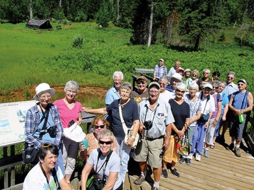
Talking about how those features got their names is a good way to combine geology and history – and was the theme of a bus tour of the park hosted by Roland Neave last Saturday.
The tour was a fundraiser for Wells Gray World Heritage Year. Nearly three dozen people, most of them from Kamloops, took part.
Up until the 1960s Spahats Creek was known as Bear Creek, Neave said.
The people in Victoria responsible for place names decided there were already too many Bear Creeks in the province and so changed the name to Spahats, which is Chinook jargon for bear.
The name for the waterfall on the creek also changed and is now Spahats Falls.
Garnet Peak, at 9,500 feet, is the highest mountain in Wells Gray Park. It is visible from the Clearwater Valley lookout near Spahats Falls, even though it is 75 miles away.
It was first climbed by Roland Neave's father, Hugh Neave, and two others in the early 1970s. Hugh Neave named it for the garnets he found on its slopes.
Pillpill and Killpill mountains, also visible from the lookout, sound similar but have different origins. Pillpill is a native word for the colors found in mineral springs there. Killpill was named for cyanide capsules used to kill wolves in the 1930s.
Grouse Creek started out as Beaver Creek, then became Grouse Creek, then Moul Creek, and is now Grouse Creek again.
It is about a one hour hike to Moul Falls, which were named for Alfred Moul, an early homesteader.
The Flatiron Trail takes people from the road to the Flatiron, a volcanic feature that resembles an old style clothes iron.
Pyramid Mountain resembles a pyramid because it is a volcano created by an eruption under glacial ice that was 3/4 mile thick.
The first documented sighting of Helmcken Falls was by surveyor Robert Lee in 1913. He wrote to  Premier Sir Richard McBride and suggested it be named McBride Falls. The premier declined the offer and suggested instead that it be named for Dr. John Sebastian Helmcken.
Helmcken was an amazing man, said Neave, and even though he never saw the falls named after him, it was probably an appropriate choice.
John Ray came to what is now Wells Gray Park from Oregon in 1911.
That winter he and his brother, Sam, stayed in a cave by Azure Lake as they trapped.
The next year John Ray apparently helped save many members of the Canim Lake Indian Band during a measles epidemic.
In gratitude the chief awarded him a huge tract of land, about 800 acres, centred around what is now called the Ray Farm.
The first few years he stayed in a cabin near what is now Alice Lake.
He then built a one-room cabin next to the mineral springs on the farm.
In 1933 he surprised many by marrying Alice Ludtke, daughter of an Upper Clearwater pioneer family. He was 50 years old while she was just 21.
The couple had three children and, in 1940, Ray built a new, larger cabin.
 The family moved out in 1947 so the children could get a better education. John Ray made a trip into the farm that fall. A search party later found him dead of an apparent heart attack between the house and the barn. He was buried nearby.
Alice died in 1959 of cancer. Her ashes were left on John's grave.
All three children did well in life. They occasionally returned to paint the picket fence around their parents grave.
Lonespoon Creek was named by John and Sam Ray during the winter of 1912. They were camping at the creek and realized they had only one spoon between them. They carved a second one out of wood.
Bailey's Chute was named for Jim Bailey, the person who designed the first real bridge over the Murtle River (no connection to the Bailey bridges often used in emergency situations). In the early 1950s he was looking for a road route to the Caribou and decided the chute was the best place for a bridge. Bailey was drowned when his boat flipped just below the rapids named after him.
Wells Gray Park was named for Arthur Wellesley Gray, who named it after himself when he created it in 1939.
Gray asked ministry employee Chess Lyons to survey the new park (Lyons later wrote “Trees, Shrubs and Flowers to know in British Columbia”). The minister gave him a list of friends and political allies that he wanted features named after.
Lyons did not agree with this approach and instead named most features after local pioneers.
Those on the list got the occasional swamp or whatever named after them.
As he got to the end of his time, Lyons realized that he needed at least one prominent feature named after someone on the list, and so named Goodwin Falls.
It took Neave quite a bit of trouble, and help from the Akriggs, authors of “1001 British Columbia Place Names,” to find that Goodwin was a Spokane dentist who had once helped Gray with his teeth.
According to Neave, the bus tour plus sales of his book, Exploring Wells Gray Park, raised $1,060 for the Wells Gray World Heritage Year.
Neave also led a walk to the south rim of Helmcken Falls on Wednesday.
The next Wells Gray World Heritage event will be Wildcrafting with Sharon Neufeld on Saturday, Aug. 3. Participants should meet at Upper Clearwater Hall at 10 a.m. and be prepared to spend all day learning about useful plants. Donations will be accepted.