Could there be a better way to celebrate the 100th anniversary of the discovery of Helmcken Falls than to hike to its brink along the south rim trail? With Roland Neave as knowledgeable leader, on a sunny day with few insects and a group of lively, interested hikers – nope!
A century ago, surveyor Robert H. Lee noted the existence of a huge waterfall “with a drop of at least 450 feet” on the Murtle River. (Were First Nations people there first? Perhaps, but it appears they did not frequent this area.)
At Upper Clearwater hall on July 24, Roland Neave, author of Exploring Wells Gray Park, gave the well-researched details, in a concise, thought-provoking, sometimes amusing lecture to some 30 attentive attendees from Clearwater, Kamloops and elsewhere. Lee’s report enthused about the whole area, including recommending much of it, despite its elevation and heavily wooded growth, as “prime agricultural land”. Maybe not… “We’ll look at the probable position of Camp 9, where he and perhaps six assistants stayed while surveying lots in the area,” Roland explained, adding, “and July 24 is the date of his discovery of these impressive falls.”
Despite his many contributions to the development of Kamloops and remarkably accurate surveys of lots on Murtle Plateau and in Upper Clearwater, only one narrow street, four blocks long, in Kamloops, bears his name. A cairn of rocks, a post planted in the middle, indicated corners of lots, some of which still remain.
“Their positions have been checked with the latest technology,” Roland commented, “and those original markers are only centimetres off the dot.”
We hikers roundly supported Neave and Trevor Goward’s suggestion that the small waterfall below Helmcken Falls be named Lee Falls in his honour.
Leaving the hall (and Ellen Ferguson who had graciously supplied hot beverages and goodies), the convoy car-pooled to the trailhead above Murtle River and its swirling Mushbowl. Goward told us a short story before we set off to hike the mainly level, four km trail to an unfenced view of the falls and its yawning canyon.
“I’d stop my groups of students once we could hear the falls and feel the reverberation,” he said. “Then I would tell them: ‘It takes six seconds for a drop of water to fall from top to bottom’. I’d count off that time while they imagined that descent. I never had any trouble getting them to stay back from the edge!”
Roland remembers encouraging photographers to lie on their stomachs to get good shots.
“However,” he added, “we came back a year later and that shelf had fallen away. There’s nothing underneath,” he emphasised. “That spraying water is continually carving.”
Okay – we’d been warned….
While not a difficult trail, rocks and roots underfoot kept us looking down rather than gawking at the tall trees and thick underbrush (including plump huckleberries) through which Robert Lee and his men had dragged survey chains, somehow keeping them in alignment. Partway along, Roland called a halt.
“From Lee’s map,” he explained, “I figure this was the site of Camp 9. Perhaps their garbage dump could be found with a metal detector. A study of ages of trees might provide another clue, for they probably cleared a small area.”
We looked around, enthralled, trying to picture the scene in 1913. Murtle River chattered musically along nearby, as it does for much of the trail – until the big drop.
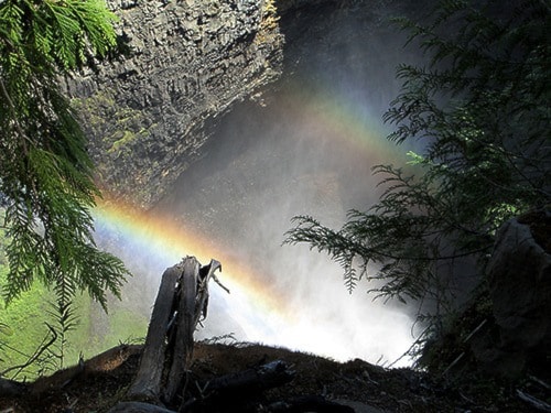
Swirling mist, changing sound and some vibration heralded our arrival. Photographs were taken – carefully. A double rainbow provided an extra bonus to the well-known sight of this awesome waterfall, though now from a closer viewpoint and different angle. Across the majestic canyon it has created, visitors from far and near stood behind safety fences to marvel at the sight.
No wonder Robert Lee marvelled. He suggested it be named after then-premier Richard McBride; he in turn insisted that it honour Dr. J.S. Helmcken, who had played a major role in BC’s becoming part of Canada.
This was a great tribute indeed, but we were so much more fortunate than he was – we saw Helmcken Falls; he did not. We viewed them in glorious sunshine, commemorating the day when Robert H. Lee found them exactly 100 years earlier.
Below: Participants in a Wells Gray World Heritage Year hike to the south rim of Helmcken Falls check for signs of previous habitation at the apparent site of Camp 9, the place where surveyor Robert H. Lee was based out of when he made the first recorded discovery of Helmcken Falls in 1913.
